
TAKE A HIKE
Trail notes, outdoor inspiration, and strength
for the life you want to live.
the trail is where i come alive.
Hiking is where I breathe deeper, clear my head, and remember how good it feels to move through the world with strength and freedom. It’s where I find perspective, notice God’s beauty, and feel fully present in the life right in front of me.
Here I’m sharing the trails I explore, the notes I take along the way, and the simple strength that helps us keep saying yes to adventure — one trail at a time.
TRAIL NOTES from boise & beyond
Exploring one trail at a time.
The trails I’m exploring around Boise—where I went, what I noticed, and what I’d want to know before going again.
BOISE TRAILS
-
MY ROUTE TODAY
Trail System: Boise River Wildlife Management Area
Trail: Adelmann Mine
Distance: 4.28 miles
Elevation Gain: 1,109 ft
Difficulty: Moderate
Time on trail: 1:52
Route: Out and backTRAIL NOTES
From the Trail: Sunshine, trickling streams, birds, and chipmunks along the way. The climbs were tough and definitely got my legs working, but the views were incredible.
The Environment: Beautiful views and a climb tha tleads to something unexpected: an old mine tucked into the hillside. Coming across it was so cool.
Finding Joy: I had the trail to myself on the way up and got to take in the views and explore the area around the mine. I passed several people and dogs heading up as I made my way back down. A good climb, a little history, and a beautiful day outside made this one a favorite.
GOOD TO KNOW
Crowd Factor: I didn’t see anyone on the way up, but passed several hikers and dogs on the way down.
The Climb: Be ready for some challenging uphill sections and a descent on the way back.
At the Mine: Enjoy the old structures from a safe distance and stay out of mine openings and unstable buildings.
Parking: There was a small, free parking area, and it was easy to find a spot when I visited. When I left, it was full.
STRENGTH FOR THE TRAIL
Keep Climbing: A sustained uphill asks your legs to keep working even when they’re tired. Try a set of walking lunges or a steady climb on stairs to practice finding a rhythm.
Control the Descent: Going downhill calls for control with each step. Try reverse lunges, lowering slowly before pressing back up.
Go the Distance: Building your walking endurance helps you feel ready for longer stretches on your feet. Start with a distance that feels manageable and gradually add time or hills.
-
MY ROUTE TODAY
Trail System: Ridge to Rivers
Trail: Sweet Connie
Distance: 4.30 miles
Elevation Gain: 787 ft
Difficulty: Easy to Moderate
Time on trail: 1:38
Route: Out and backTRAIL NOTES
From the Trail: Open foothills, beautiful views, a few trees showing their fall colors, and some incredible rock formations. The trail had plenty of ups and downs, and I even stopped to climb around on a few boulders just for fun.
The Environment: Cool air, sunshine, a gentle breeze, and the most incredible clouds made this feel like the perfect fall day. Everything was so still and quiet. I could hear the birds, the breeze, and the sounds of nature all around me.
Finding Joy: I had almost the entire trail to myself. I didn’t see anyone until I passed a woman jogging with her dog near the end. Fresh air, movement, a little adventure, and absolutely nowhere else I wanted to be.
GOOD TO KNOW
Crowd Factor: It was incredibly quiet when I hiked. I only saw one other person near the end, though your experience may be different.
Terrain: Expect rolling terrain with climbs and descents, open foothill views, and rock formations along the way.
Weather & Layers: It was cool with a gentle breeze on my October hike. Layers can be helpful as the weather changes.
Parking: Parking was free and plenty of space was available.
STRENGTH FOR THE TRAIL
Climbing Strength: Step-ups and split squats help build strength for the uphill sections.
Balance & Stability: Single-leg balance exercises and suitcase carries can help you build stability for changing terrain.
Downhill Control: Slow step-downs can help you practice controlling your movement on descents.
-
MY ROUTE TODAY
Trail System: Hulls Gulch Reserve
Trail: Kestrel, Crestline & Lower Hulls Gulch Loop
Distance: 5.52 miles
Elevation Gain: 650 ft
Difficulty: Easy to Moderate
Time on trail: 1:57
Route: LoopTRAIL NOTES
From the Trail: Open foothills, dirt trails, rocks, boulders, and a few trees showing their fall colors. A trickling stream along the way was a nice surprise.
The Environment: Sunshine, fresh air, and a steady climb made for a beautiful day outside. I saw lots of hikers, a few skilled mountain bikers, and some deer!
Finding Joy: Nothing particularly eventful happened on this hike, and that was exactly what I needed. I just moved, breathed deeply, and took in my surroundings. No rush. Just being.
GOOD TO KNOW
Crowd Factor: I saw lots of hikers and a few mountain bikers on the day I visited.
Navigation: This loop connects several trails, so using the AllTrails map can help at the junctions.
Terrain: Expect dirt trails, rocks, boulders, and a steady climb through the foothills.
Parking: Parking was free and the lot was completely full.
STRENGTH FOR THE TRAIL
Climbing Strength: Step-ups and split squats help build strength in your legs for steady climbs.
Single-Leg Stability: Uneven terrain and rocks challenge your balance. Single-leg exercises can help you feel more stable on the trail.
Downhill Control: Slow, controlled step-downs can help you practice managing descents.
-
MY ROUTE TODAY
Trail System: Upper Dry Creek Headwaters
Trail: Ponderosa Pine Overlook #LT5, Doug Fir Loop #LT3, Snowshoe Hare Loop #LT4, Ponderosa Pine Overlook #LT5
Distance: 4.41 miles
Elevation Gain: 676 ft
Difficulty: Easy to Moderate
Time on trail: 1:34
Route: LoopTRAIL NOTES
From the Trail: Pine trees, pinecones, boulders, butterflies, chipmunks, birds, and beautiful fall colors. Green everywhere! The cool breeze and sounds of the forest reminded me of being up north in Michigan.
The Environment: Beautiful forest, rocky terrain, changing leaves, and sunshine filtering through the trees. Listening to the wind in the pines and wildlife rustling nearby made everything feel so alive.
Finding Joy: Near the end I met two gentlemen in their 70s. I congratulated them on staying active. One proudly showed me the pacemaker he’d had put in just a week earlier! As I walked away, they called out, “Bye, hun!” and I couldn’t help but smile. Between the peaceful forest and unexpected connectios, this hike was exactly what my soul needed.
GOOD TO KNOW
Crowd Factor: Incredibly peaceful! I met one hiker at the trailhead who kindly shared some advice and only encountered two others during my hike.
Navigation: Several connecting trails make up this loop. Download your map beforehand and pay attention at junctions.
Weather & Layers: It was windy and cool in October, especially among the trees. Layers were helpful, even with the sunshine.
Terrain: Forest singletrack with pine needles, rocks, boulders, and changing elevation.
STRENGTH FOR THE TRAIL
Single-Leg Stability: Uneven ground, rocks, and changing trail surfaces challenge your balance. Step-ups and single-leg exercises help build the strength and control to move confidently.
Climbing Strength: The rolling elevation calls on your glutes, quads, and calves. Split squats and step-ups build strength for the climbs while helping you control the descents.
Core Control: Navigating rocky singletrack requires stability through your trunk and hips. Suitcase carries and Pallof presses help you stay balanced and controlled as the terrain changes.
-
MY ROUTE TODAY
Trail System: Ridge to Rivers
Trail: 8th Street Motorcycle Trail #4
Distance: ~4 miles
Elevation Gain: 800+ ft
Difficulty: Moderate to Hard
Time on Trail: ~1:30
Route: Out + back*My tracker paused during this hike, so distance, elevation and time are approximate.
TRAIL NOTES
From the Trail: This trail kept me working — descend, climb, drop again, climb again, then turn around and do it all in reverse. The constant ups and downs made it a surprisingly challenging workout.
The Environment: Classic Boise foothills with mostly wide-open sun, pockets of shade, dry terrain, and loose, slippery rocks underfoot.
Finding Joy: No summit or big destination today — I just wanted something hard. I loved being able to go until I was ready, turn around, and let the trail be exactly what I needed that day.
GOOD TO KNOW
Make It Your Own: This works really well as an out-and-back. Pick your time or turnaround point and retrace your route.
Bikes, Motorcycles & Dogs: This is a multi-use trail. I saw lots of cyclists, a few motorcycles, dogs, and only one other hiker.
Sun + Shade: Mostly wide-open and exposed, with a few welcome pockets of shade along the way.
Watch Your Footing: Parts of the trail are dry, rocky and loose. The changing elevation combined with slippery rock makes good traction especially helpful on the descents.
One Important Note: AllTrails currently lists an 8th Street Motorcycle and East Sunset Peak Loop [CLOSED]. That is not the route I hiked. I stayed on 8th Street Motorcycle Trail #4 and used a portion of the trail as an out-and-back.
STRENGTH FOR THE TRAIL
Downhill Control: Strong quads and the muscles surrounding your knees help you control the repeated descents instead of simply absorbing them.
Climbing Power: Glutes, hamstrings, calves, and the rest of your posterior chain help drive you back uphill every time the trail turns up again.
Stability From the Ground Up: Strong feet, ankles, Achilles, and core help you stay balanced and adjust to loose rock, changing grades, and uneven terrain.
-
MY ROUTE TODAY
Trail System: Ridge to Rivers
Trail: Dry Creek Trail #78
Distance: 3 miles
Elevation Gain: 322 ft
Difficulty: Easy to Moderate
Time on trail: 1:16
Route: Out and backTRAIL NOTES
From the Trail: Wild berries, changing leaves, flowers, butterflies, grasshoppers, and birds — this canyon is absolutely bursting with life.
The Environment: A perfect combination of bright sunshine and cool shade, featuring beautiful green forest trees growing right down to the water’s edge alongside rugged boulders and rolling hills.
Finding Joy: I actually planned a different trail today, but a Mom from school recommended this one instead. It brought me so much joy and is officially my new favorite Boise hike!
GOOD TO KNOW
Crowd Factor: It wasn’t crowded at all — I only saw a handful of hikers/bikers the entire time, making for a very peaceful trek.
Bikers & Dogs: It is a multi-use path shared with mountain bikers and is popular for dogs.
Parking: Very small dirt pullout on Bogus Basin Road, go early on weekends.
STRENGTH FOR THE TRAIL
Ankle Stability: Single-leg balance work preps you for the rocky singletrack and boulders.
Edge-of-Trail Control: Pallof presses and suitcase carries build tight core control, keeping you steady and balanced when navigating narrow singletrack along steep edges.
Downhill Brakes: Slow, eccentric squats protect your knees on the rolling return trip.
-
MY ROUTE TODAY
Trail System: Table Rock Reserve
Trail: Table Rock #15
Distance: 3.37 miles
Elevation Gain: 876 ft
Difficulty: Moderate
Time on trail: 1:21
Route: Out and backTRAIL NOTES
From the Trail: Short and sweet—but basically up, up, up! 😅 Reaching the top and suddenly seeing the cross opens up into an incredible view of the whole city spread out below.
The Environment: A wide-open, completely sun-drenched incline climbing straight through high-desert terrain, native sagebrush, and rugged sandstone cliffs.
Finding Joy: This wasn’t the hike I planned today; I had a much longer one in mind, but life needed some other things from me, so I changed course. Sitting at the top, taking in the view, and reading the story behind the cross reminded me that sometimes changing the plan doesn’t mean you missed what you needed—maybe it leads you right to it.
GOOD TO KNOW
Crowd Factor: It was fairly busy—I saw and passed about 30ish people along the way, but it still felt totally fine and didn’t take away from the experience.
Parking: There is a large gravel lot with plenty of parking spaces right at the Old Idaho Penitentiary Trailhead. It is completely free to park here, making it super easy to access the base of the trail.
Sunset Rules: Keep in mind that the entire Table Rock area strictly closes from sundown to sunup for safety. The main parking lot gate automatically shuts at sunset (it will still open to let parked cars exit, but you can't enter after dark).
Mud Management: The soil on Table Rock Trail #15 has a very high clay content. If it has rained recently and the trail is muddy, you have to skip it to avoid damaging the tracks. Always check the Ridge to Rivers trail status online before heading out!
STRENGTH FOR THE TRAIL
Continuous Incline Stamina: High-volume step-ups, lunges, and calf raises will prepare your legs for that immediate, relentless "up, up, up" push to the top.
Sandstone Trailing & Footing: Single-leg balance work and lateral ankle-strengthening drills will give you the stability needed to comfortably navigate the flat, rocky sandstone cliffs and loose dirt near the summit.
Sun-Exposed Endurance: Because this trail features absolutely zero shade and fully absorbs the Boise sunshine, focused aerobic conditioning and bringing plenty of water are key to keeping your energy high.
-
MY ROUTE TODAY
Area: Boise River Wildlife Management Area
Trail: Cervidae Peak
Distance: 4.58 miles
Elevation Gain: 1,909 ft
Difficulty: Hard
Time on trail: 2:33
Route: Out and backTRAIL NOTES
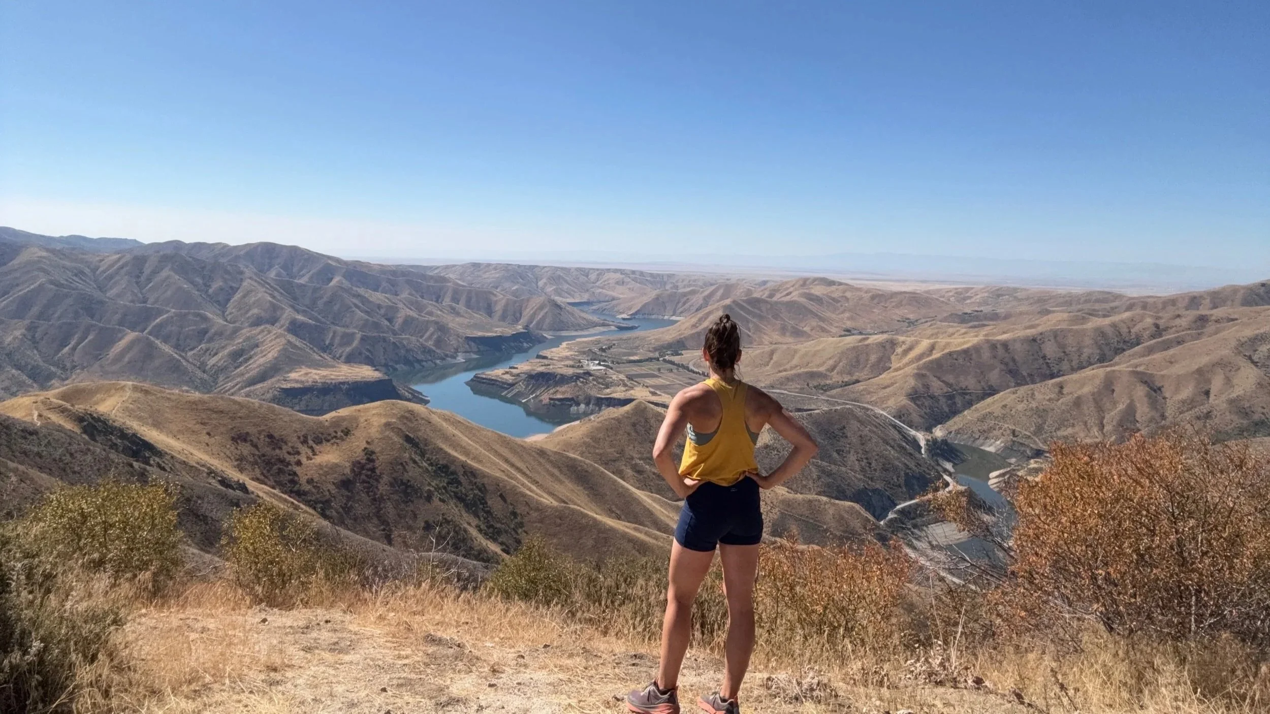
From the Trail: Up, up…and more up! 😅 It was a relentless climb, but the jaw-dropping view at the top was worth every single burning step.
The Environment: A rugged, punishingly steep ridge scaling straight through the dry, golden beauty of the Boise foothills. Once you conquer the final incline, it opens up into mountains rolling out in every single direction—and the stunning, deep blue water of Lucky Peak Reservoir stretching out below you.
Finding Joy: I’ve really been craving water lately. Standing at the peak, soaking in the panoramic vistas, and seeing all that vibrant blue beneath me felt like exactly what my soul needed. I stayed at the top for quite a while, met a fellow hiker and his dog, and just took it all in. God’s creation is pretty incredible.
GOOD TO KNOW
Crowd Factor: This trail feels far more remote than the lower foothills. I only ran into one other hiker and his pup at the summit, allowing for a deeply peaceful and reflective experience.
Parking: Located about 35 minutes outside of Boise past Lucky Peak Dam. You will park in a large dirt pull-out on the right side of Arrowrock Road / FS-269 (just a couple of miles past the Spring Shores Marina). The unmarked trailhead starts right across the street behind a large metal gate.
No switchbacks: Be prepared mentally—this trail does not believe in switchbacks. It gains nearly 2,000 vertical feet by going entirely straight up and straight down the ridge line. The descent can actually be much tougher on your body than the climb up!
The Grand Slam: Cervidae Peak is officially recognized as part of the famous Boise "Grand Slam"—a collection of four challenging peaks locals use to train for serious mountaineering.
STRENGTH FOR THE TRAIL
Downhill Knee Brakes: Heavy eccentric squats and step-downs are non-negotiable to protect your joints and brake your body weight on the steep, quad-burning descent.
Loose Dirt & Slip Stability: The trail terrain is very dry, sandy, and full of loose gravel. Single-leg balance work, tibialis raises, and ankle mobility drills are vital to keep you from sliding on the steep grades. (Pro tip: This is a trail where trekking poles are highly recommended to save your knees and balance!)
Glute & Core Drive: Constant "up, up, up" means your posterior chain will be working overtime. High-volume hip thrusts, deadlifts, and anchored plank variations will keep your posture upright and driving forward.
-
MY ROUTE TODAY
Trail System: Polecat Gulch Reserve
Trail: Polecat Loop #81 via Collister Trailhead
Distance: 6.79 miles
Elevation Gain: 823 ft
Difficulty: Moderate (Rolling terrain)
Time on trail: 2:00
Route: LoopTRAIL NOTES
From the Trail: Up. Down. Switchbacks. And gorgeous views around almost every single turn! 🌾 It started out beautifully cool and sunny, warming up quickly as the miles went on. The trail was bursting with life—grasshoppers everywhere, a few lizards, and deer grazing along the ridges.
The Environment: A scenic, rolling loop weaving through open, golden gulches and sagebrush-covered hills. The trail offers fantastic, elevated perspectives of the surrounding foothills and valleys without being a relentless, vertical grind.
Finding Joy: There’s something about spending a couple of hours on a trail that clears my head in a way not much else does. Just moving. Climbing. Looking around. Thinking when I want to, and not thinking when I don’t. I am still getting to know these Boise trails and getting used to how different they look and feel, but I am really grateful to have places like this so close to home.
GOOD TO KNOW
Crowd Factor: This is a popular spot for locals, especially during midweek windows. Expect to share the trail with quite a few friendly mountain bikers spinning through the loops.
Parking: Accessing via the Collister Trailhead means parking in a smaller, unpaved neighborhood lot at the very north end of Collister Road. It provides a peaceful, less commercial entryway compared to some of the major Boise trailheads, but it can fill up quickly during peak hours.
Loop Navigation: The Polecat Loop connects beautifully with several intersecting trails. It's a fantastic spot if you want to log longer, continuous miles without having to do a simple out-and-back route.
STRENGTH FOR THE TRAIL
Repetitive Step Stamina: Because this is a longer loop (~6.8 miles) with constant up-and-down pacing, endurance-focused movements like high-rep bodyweight squats and long-duration walking lunges will build the muscular stamina your legs need.
Switchback Lateral Control: Navigating winding switchbacks requires core and hip stability. Incorporating lateral step-ups, side planks, and banded monster walks will keep your hips stable as you turn through the winding corners.
Aerobic Engine Conditioning: A steady two-hour trek demands consistent pacing. Zone 2 cardiovascular training—like steady incline treadmill walking or low-intensity cycling—is perfect for keeping your heart rate controlled on rolling foothills.
-
MY ROUTE TODAY
Trail System: Military Reserve
Trails: Heroes #1B → Mountain Cove #1E_A → Central Ridge #22 → Ridge Crest #22A → Cottonwood Creek #1D
Distance: 5.57 miles
Elevation Gain: 600 ft
Difficulty: Moderate
Time on trail: 1:53
Route: Loop (Started/ended at home)TRAIL NOTES
From the Trail: Quiet trails, beautiful views of the foothills and downtown Boise, and a few breezy cloud sprinkles that felt absolutely amazing. I went a little farther than planned today and eventually came out somewhere I wasn't expecting—but somewhere along Cottonwood Creek, I stumbled onto a tiny stream and instantly felt more alive.
The Environment: A vibrant network of trails offering a perfect mix of wide-open, grassy ridges and quiet, hidden creeks. There are so many distinct colors and textures out here that I’m truly learning to notice and appreciate as I explore.
Finding Joy: This was a total neighborhood adventure. A little wandering, a little adjusting, and a lot of exploring. There is something so special about being able to just lace up my shoes, walk straight out my front door, and connect right into the foothills.
GOOD TO KNOW
Crowd Factor: This trail system is a bustling community hub. It was a peaceful midweek trek, but you will definitely share the dirt with a friendly mix of local hikers, dogs, and mountain bikers.
Trailhead Flexibility: While I walked straight from home, you can easily access this exact loop from multiple official entry points. The Main Military Reserve Parking Lot off Mountain Cove Road or the Reserve Park lot off Fort Street both offer plenty of free parking and quick access to the trail connectors.
Choose Your Own Adventure: The trails here are highly interconnected and weave together quickly. It is incredibly easy to accidentally extend your mileage or pop out at a different trailhead than you intended—but that’s half the fun! Just keep an eye on the trail signs at the intersections to navigate your way back.
STRENGTH FOR THE TRAIL
Variable Terrain Agility: Moving between wide dirt paths, sandy ridges, and rocky creek sides requires quick ankle adaptation. Single-leg hops, calf raises, and multi-directional lunges will prep your lower body for changing trail textures.
Core Bracing for Steep Ridges: Central Ridge features some short, punchy climbs. Keeping your core tight with movements like bird-dogs, deadbugs, and farmers carries will help you maintain strong posture on the short inclines.
Aerobic Endurance & Recovery: Going farther than planned demands a solid aerobic engine. Building up your continuous walking or jogging stamina keeps your energy high even when you take a spontaneous detour.
-
MY ROUTE TODAY
Trail System: Camel’s Back & Hulls Gulch Reserve
Trails: Camel's Back #40 → Florence’s #43 → Red Fox #36 → Gold Finch #35 → Owl’s Roost #37 → Kestrel #39A → Red Cliffs #39 → Chickadee Ridge #36A
Distance: 3.88 miles
Elevation Gain: 446 ft
Difficulty: Moderate
Time on trail: 1:17
Route: Custom Reserve LoopTRAIL NOTES
From the Trail: Sunny, hot, and a few completely unexpected raindrops halfway through that felt absolutely AMAZING! The trails were alive with local runners, dogs, mountain bikes, and even a little lizard sunning himself along the path.
The Environment: A classic introduction to the Boise landscape—brown, dry, and completely wide open. It is a striking contrast to the lush green forests I’m used to, but those rolling mountains framing the horizon are absolutely spectacular.
Finding Joy: It’s been a while. Trail Notes originally started as a simple way for me to get outside, explore somewhere new, and notice what I noticed along the way. It feels like the right time to bring it back—maybe a little differently this time. New state, new trails, and a whole lot to explore. I'm still adjusting to this unique desert landscape, but I'm really excited to keep exploring it.
GOOD TO KNOW
Crowd Factor: This is the literal heart of the Boise foothills trail scene. Because it sits right against Camel's Back Park, expect it to be highly active and bustling with a continuous flow of friendly neighborhood trail runners, hikers, and mountain bikers.
Parking: Park at the main Camel's Back Park lot off Heron Street. It is a large, paved, free lot with full park amenities like water fountains and real restrooms. Because of how central it is, the lot fills up quickly on beautiful afternoons, but neighborhood street parking is usually a great backup.
The "Chute" Alternative: The loop traditionally starts or ends near the famous Camel's Back hill. If you want a quick, punchy heart-rate spike, you can climb the steep dirt paths (or the outdoor stairs) directly up the front face of Camel's Back before dropping into the back trails!
STRENGTH FOR THE TRAIL
Multi-Directional Agility: Hulls Gulch and Red Fox feature winding, rolling sandy tracks. Incorporating lateral lunges, ice skaters, and single-leg stability hold variations prepares your ankles to shift smoothly with the curving terrain.
Steady-State Pacing: With a gentle 446 feet of elevation spread across nearly 4 miles, this loop is perfect for developing consistent aerobic endurance. Focus on Zone 2 training to build a strong cardiovascular foundation.
Postural Core Endurance: Walking on open, sun-drenched trails requires a strong, stable core to maintain upright form as fatigue sets in. Deadbugs, standard planks, and bird-dogs will help keep your posture locked in.
BEYOND BOISE
Trails, mountain towns + outdoor adventures beyond the Boise foothills. Coming soon.
The parks we’ve explored over the years—the routes we took, the places we loved, and the memories we’re keeping along the way.
national parks
-
Who: Our family
Our Route
Oacoma → Northeast Entrance → Badlands Loop Road → WallStops Along the Way
Big Badlands Overlook
Door Trail
Ben Reifel Visitor Center
Yellow Mounds Overlook
Pinnacles OverlookWildlife Spotted
Prairie dogs, bison + pronghornTrail Notes
This was our first National Park stop on the road from Ohio to our new home in Boise, and one of the biggest surprises of the entire trip. After miles of South Dakota prairie, the landscape suddenly changed into huge rugged formations, deep canyons and layers of color.We drove Badlands Loop Road, stopping whenever something caught our attention. The boys loved climbing and exploring, and seeing prairie dogs, bison and pronghorn made it even better.
Door Trail was especially fun with the kids because it gave them a chance to get out into the landscape instead of only seeing it from overlooks.
If You’re Short on Time
Drive Badlands Loop Road and prioritize Big Badlands Overlook, Door Trail, Yellow Mounds Overlook and Pinnacles Overlook. It gives you a really good mix of sweeping views, colorful formations and a chance to actually get out and explore.Good to Know
This park works really well as a road-trip stop because so much of the experience is accessible directly from the scenic drive. You can make it as short or as long as you want depending on how many overlooks and trails you stop for.Strength for the Adventure
You don’t need a big hiking day to experience Badlands, but uneven terrain, climbing around the formations and getting in and out at multiple stops definitely reward good balance, leg strength and confidence moving over rocky ground.The Boys’ Take
Leo’s favorite: seeing the animals
Lukas’ favorite: looking around + exploringMy Favorite Memory: Watching the boys explore somewhere completely unlike anything we’d every seen before.
.
-
Who: Our family
Our Route
Day 1: Custer State Park → across Wyoming → Snake River Overlook → Jackson
Day 2: Jackson → South Jenny Lake → BoiseStops Along the Way
Snake River Overlook
Jackson Town Square + Antler Arches
South Jenny Lake
Jenny Lake Visitor Center + lakeshoreWhere We Stayed
Elk Country Inn | Jackson, WyomingTrail Notes
Grand Teton was our second National Park on the road from Ohio to our new home in Boise — and our final adventure before officially arriving in Idaho.After a LONG drive across Wyoming, we reached Grand Teton National Park in the evening. Our first stop was Snake River Overlook, where we got our first real look at the Teton Range.
WOW.
After so many hours in the car, seeing those mountains suddenly rising in front of us felt pretty surreal — especially for the boys.
We spent the night at Elk Country Inn in Jackson, walked around town for a bit, let the boys pick out a couple souvenirs and, of course, stopped by the famous antler arches. They even squeezed in a quick swim before we headed to bed to get ready for Jenny Lake the next morning.
And then we woke up to rain + thunder.
I was so disappointed because Jenny Lake was the one place I really wanted to experience before leaving. Thankfully, by the time we were ready to go, the storm had settled into a sprinkle.
So we went anyway.
We parked near the Jenny Lake Visitor Center, walked down to the lakeshore and explored for a while. It was cloudy, misty and definitely not the picture-perfect morning I had imagined — but somehow that made it memorable in its own way.
I am SO glad we went.
Standing at Jenny Lake felt especially meaningful knowing it was the last morning of our cross-country journey.
Next stop: Boise → home.
If You’re Short on Time
If you only have a few hours in Grand Teton, I’d prioritize Snake River Overlook + Jenny Lake.Snake River Overlook gives you that huge, iconic view of the Teton Range with almost no time commitment, while Jenny Lake gives you a chance to actually get out, walk to the water and experience the landscape up close.
We only scratched the surface of this park, but those two stops gave us two completely different experiences.
Good to Know
Grand Teton is a park I would absolutely give more time to on a future trip. There are so many overlooks, lakes, hikes and wildlife areas that trying to “do it all” in a few hours would be impossible.If Jenny Lake is on your list, go early. It gets busy, and an early start also gives you more room to slow down and enjoy the shoreline.
And don’t automatically give up because of imperfect weather. Our rainy, misty morning ended up becoming one of my favorite memories of the trip.
Strength for the Adventure
You don’t need a major hike to enjoy Grand Teton, but even a simple morning at Jenny Lake involves plenty of walking, uneven ground and time on your feet.This is exactly the kind of adventure I want strength for — being able to get out of the car after a long travel day, explore with my family, walk down to the lake and say yes to whatever the day gives us.
The Boys’ Take
Leo’s favorite: visiting Jenny Lake
Lukas’ favorite: seeing the mountainsMy favorite memory: watching the boys throw rocks into Jenny Lake on the last morning of our journey west.
-
Notes in Progress. I’m adding my route details, what to know, and the things I loved about this hike soon.
-
Notes in Progress. I’m adding my route details, what to know, and the things I loved about this hike soon.
-
Notes in Progress. I’m adding my route details, what to know, and the things I loved about this hike soon.
-
Notes in Progress. I’m adding my route details, what to know, and the things I loved about this hike soon.